 John Veale Solicitor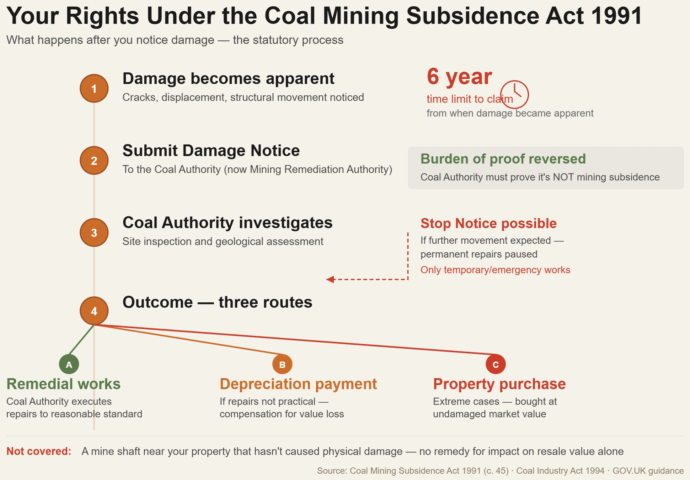
A total of about 7 million properties in England, Scotland and Wales lie within coalfield boundaries. Of these, about 1.5 million are directly above mine workings at depths 30 metres or less. And there are at least 172,000 coalmine entries — shafts and adits — formalized in records. Those figures are from a 2016 parliamentary debate on Coal Authority compensation procedures, and they haven’t shrivelled since.
When the coal industry was nationalised in 1947 there were 234 active collieries just in County Durham. Northumberland had dozens more. The last pits in the region — Seaham, Vane Tempest, Easington, Westoe, Monkwearmouth, Wearmouth — all shut between 1992 and 1994. There are no longer any mines, but the ground under those houses still remembers.
If you are purchasing property in any part of the North East, your solicitor will almost certainly request a CON29M coal mining report as one of the conveyancing searches. What that report includes, what it means if something gets flagged, and what your legal options are if subsidence damage emerges later — that’s what most buyers don’t adequately get explained until it’s too late.
What the CON29M Actually Checks
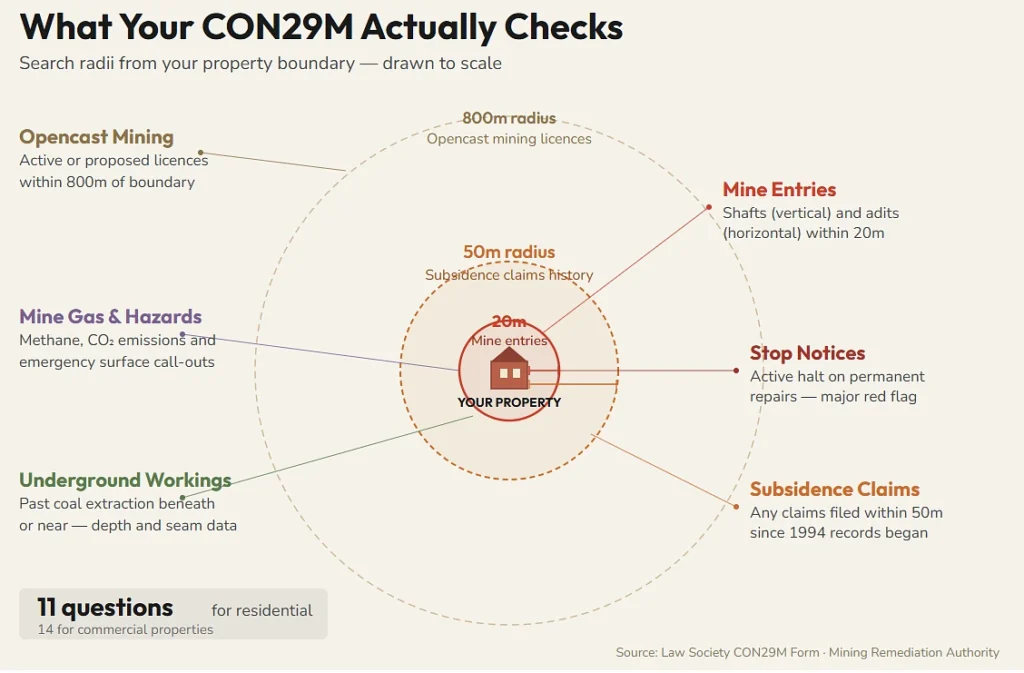
The CON29M is a Law Society form. It pulls official data from the Coal Authority (now operating as the Mining Remediation Authority) and reports on past, present, and future coal mining activity that could affect a specific property. Your solicitor orders it as part of the standard conveyancing search pack whenever the property falls within a coal mining reporting area — and in the North East, that covers most of the region.
The report answers 11 questions for residential properties (14 for commercial). Each one targets a different category of mining-related risk:
- Past underground mining. Whether coal has been extracted beneath or near the property. The report identifies worked seams and estimated depths. Shallow workings — anything less than 30 metres — are the ones that cause the most concern because they’re close enough to the surface to affect structural stability.
- Mine entries within 20 metres. Shafts (vertical) and adits (horizontal tunnel entrances) within 20 metres of the property boundary. A shaft can range from a few metres deep to hundreds of metres. Adits are the kind of thing that gets bricked up and built over, then resurfaces decades later when the ground above shifts.
- Geological faults and fissures. Natural fractures in rock that coal extraction can reactivate. When a fault moves, it can cause vertical displacement at the surface — which translates to cracked walls, jammed doors, uneven floors.
- Subsidence claims within 50 metres. Whether anyone nearby has filed a subsidence damage claim with the Coal Authority since 1994 (when they started keeping records in the current format). If the house next door submitted a subsidence claim eight years ago, that’s information you’d want before signing a contract.
- Mine gas emissions. Disused coal mines can release methane, carbon dioxide, and other gases. The Coal Authority records incidents where gas emissions required remediation. This one is less common but worth noting — mine gas doesn’t respect property boundaries.
- Opencast mining within 800 metres. Whether any opencast licence has been granted or is being considered for land near the property.
- Stop notices. A stop notice under the Coal Mining Subsidence Act 1991 means the mine operator or Coal Authority has told the property owner to hold off on permanent repairs because further subsidence movement is expected. An active stop notice on a property you’re about to buy is a significant red flag.
- Emergency surface hazard call-outs. Times when the Coal Authority has been called to the property because of an urgent surface hazard — a collapsed shaft, ground giving way, that sort of event.
The 99% Pass Rate — and the 1% That Matters
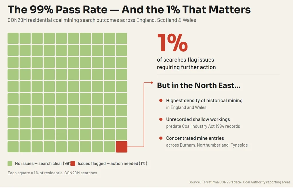
Data from Terrafirma, one of the licensed CON29M providers, indicates that approximately 99% of residential coal mining searches return with no issues requiring any further action. That’s reassuring in theory, and for most purchases it is. The search returns clear, the solicitor checks the box, the transaction proceeds.
But the North East has a very large chunk of that last 1%. The concentration of historic mines in Durham and Northumberland, the volume of unlisted shallow workings, and just the high proportion of mine entries to surface area means that where something is flagged it is usually exactly in the areas people are buying houses.
The same report, when a mine entry is detected within 20 metres of the property would previously recommend an extra Mine Entry Interpretive Report at an extra fee — approximately £150. Some CON29M providers already include this interpretive assessment as standard. The interpretive report finds a “zone of influence” for each mine entry — the physical area or footprint over which the entry could present a stability risk — and incorporates that into the overall risk assessment.
What Happened at West Allotment, Shiremoor
This one is worth knowing about if you’re buying in the wider Newcastle area.
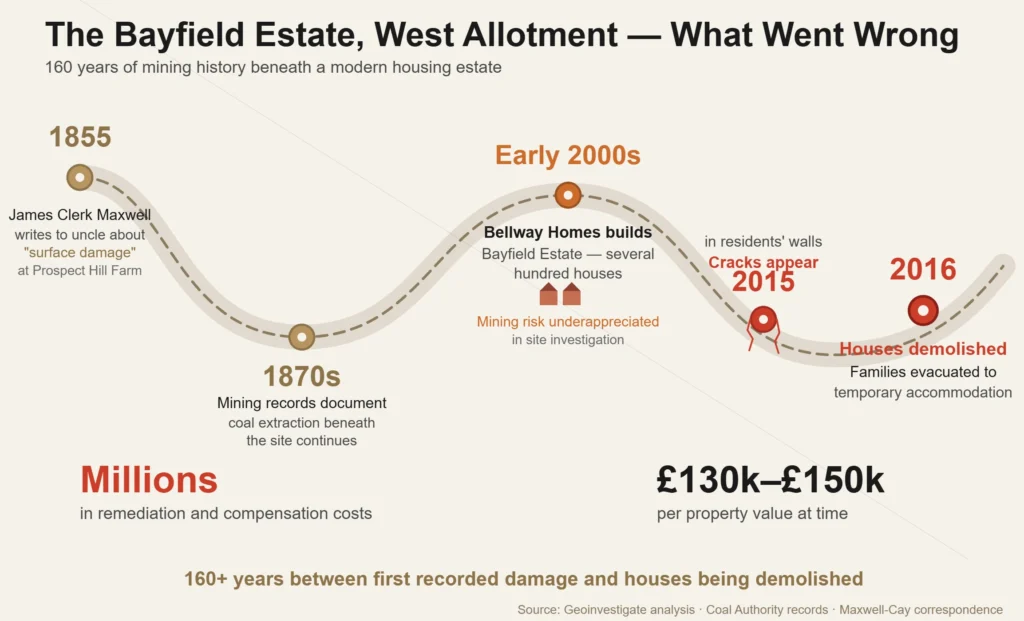
The Bayfield Estate at West Allotment, Shiremoor, is a relatively modern development — part of a larger scheme of several hundred houses built by Bellway Homes on the east side of Newcastle. In 2015, residents started noticing cracks appearing in their walls. By 2016, families were being moved out of their homes into temporary accommodation. Houses were demolished.
The Coal Authority blamed the damage on subsidence from historical coal mining. Geoinvestigate, a firm specializing in such investigations, was one of several companies that had been asked for comment on the matter and concluded that: “It is likely that coal mining under part of the site was missed or underestimated” during the original site investigation conducted when they were looking to develop the new siting around 2000. No one had adequately identified mining subsidence as a hazard to the new houses, and the design of the building did not account for unstable mine workings.
Each property was valued at between £130,000 and £150,000. The remediation and compensation reportedly cost millions. Residents not directly affected worried about property blight — the challenge of selling a house in an estate where neighbouring homes had been razed because the ground beneath them was unstable.
Historical records uncovered by the investigation extended back to the 1870s. As early as 1855, correspondence between the scientist James Clerk Maxwell and his uncle Robert Dundas Cay, owner of Prospect Hill Farm (the land on which Bayfield Estate now stands), mentioned a claim for “surface damage” — then known as mining subsidence.
The cautionary element is the gap between what was known historically and what the initial site investigation detected. A CON29M search in the context of conveyancing may have alerted to the risk. Asking whether the original purchasers were warned about it, and what diligence their solicitors undertook, are for another day — but explain why the coal mining search isn’t an optional extra in North East conveyancing. It’s the search that saves you from purchasing someone else’s subsidence issue.
The Coal Mining Subsidence Act 1991 — Your Rights If Damage Shows Up
If your property suffers subsidence damage caused by coal mining, the Coal Mining Subsidence Act 1991 (as amended by the Coal Industry Act 1994) creates a statutory framework for getting it repaired or compensated. This isn’t something you pursue through your buildings insurer in the normal way — the Act places the obligation on the mine operator or, where the operator no longer exists (which is most historical mining), the Coal Authority.
- Who can claim: Property owners, and tenants who are responsible for repairs and maintenance. If you’re a leaseholder responsible for structural upkeep, you likely have standing.
- What the Coal Authority must do: Their primary obligation is to execute remedial works — repairs that make good the subsidence damage to a reasonable standard. If repairs aren’t practical, they may pay compensation instead (a “depreciation payment” reflecting the reduction in property value). If the property becomes uninhabitable, the Coal Authority may have to provide or pay for alternative accommodation. In extreme cases, they can be obligated to purchase the property at its undamaged market value.
- Time limit: Claims must be submitted within 6 years of the damage becoming apparent. And “apparent” is doing real work in that sentence. The clock starts from when it was reasonable for you to have known about the damage — not when the mining actually occurred. Subsidence from shallow workings can take decades to manifest.
- The burden of proof quirk: Under the Act, once a claim is made, it’s on the mine operator or Coal Authority to prove that the damage is not caused by coal mining subsidence. The burden sits with them, not you. That’s an unusual reversal from most civil claims and it matters practically — you don’t need to independently prove the geological cause before submitting your Damage Notice.
- Stop notices: The Coal Authority can defer repairs if they believe further subsidence movement is likely. A stop notice pauses the obligation to carry out permanent repairs until the movement stabilises. During that period, only temporary or emergency repairs happen. This can leave homeowners in limbo for months.
- Costs: Successful claimants can recover costs reasonably incurred in pursuing their claim, though this doesn’t cover your own time unless you can show actual wage loss with employer certification.
One thing the Act explicitly doesn’t cover: compensation for the mere existence of a mine shaft near your property. If there’s a shaft 15 metres from your house but it hasn’t caused any physical damage, the Act gives you no remedy for the impact on your property’s resale value. The anxiety is real. The legal remedy isn’t.
Indemnity Insurance — When the Search Flags Something
Not every flagged CON29M result kills a transaction. In many cases, the route forward is indemnity insurance — a one-off policy that covers the buyer (and often the mortgage lender) against financial loss arising from a specific identified risk.
Common scenarios where mining-related indemnity insurance comes into play:
A mine entry is identified within the zone of influence but hasn’t caused any recorded damage. The lender wants assurance that if subsidence occurs in the future, there’s financial protection in place.
The property has a historical subsidence claim recorded within 50 metres. No current damage, but the lender or buyer wants cover against recurrence.
Shallow coal workings are identified beneath the property but no surface effects have been documented. The risk is theoretical rather than active, but it’s enough to make a mortgage underwriter uncomfortable.
The cost of mining-related indemnity insurance varies — typically between £50 and a few hundred pounds for residential properties — and it’s usually a one-off premium that covers the property for as long as the buyer owns it. Some CON29M providers include loss-of-value insurance of £50,000 or £100,000 as standard with their report.
The solicitor’s role here is explaining what the indemnity actually covers, what it doesn’t, and whether proceeding with the purchase on the back of an indemnity policy is a reasonable decision given the specific risk profile. A policy that covers “future subsidence damage” sounds comprehensive until you read the exclusions. Getting proper legal advice on the wording — not the estate agent’s reassurance that “everyone gets one of these” — is the difference between genuine protection and a piece of paper that gives you a false sense of security.
Why North East Conveyancing Has This Extra Layer
If your solicitor isn’t ordering a coal mining search, it’s because you’re buying a terraced house in central London. Instead, the searches that count there are things like basement developments on neighbouring properties, Thames Water infrastructure and Crossrail proximity. The conveyancing process is structurally the same but substance of what gets checked is quite different fo steer with local geography and history.
This is coal country, the North East. Has been since the Middle Ages, industrially from the 1700s. Known as some of the oldest collieries in the world, the ground under Sunderland, Gateshead, South Shields, parts of Tyneside and most of County Durham and large swathes of Northumberland is littered with old workings abandoned shafts and seams that were extracted at depths which would make a modern structural engineer wince. Some of it is well-documented. Some of that goes back further than the record-keeping requirements introduced along with the Coal Industry Act 1994. And some of it — the “probable workings” dataset that the Coal Authority maintains — is an educated guess as to where coal was likely mined before anyone bothered taking notes.
That’s why the quality of your reliable Conveyancing North East solicitor matters more than in regions where the search pack is routine. A local firm that handles dozens of these transactions a month knows what a flagged CON29M looks like in practice, knows which issues mortgage lenders will accept with indemnity insurance and which ones will trigger a valuation downgrade, and knows when to push back on a seller who insists everything is fine when the mining report suggests otherwise. A national conveyancing factory processing applications from a call centre in another part of the country doesn’t have that granular knowledge — and in the North East, granular knowledge of what’s literally under the ground is the whole point.
References
- Coal Mining Subsidence Act 1991 (c. 45) — https://www.legislation.gov.uk/ukpga/1991/45
- Coal Industry Act 1994 (c. 21), Section 57 — statutory duties of the Coal Authority including provision of mining reports.
- GOV.UK, “Coal mining subsidence damage — a guide to your rights” — https://www.gov.uk/government/publications/coal-mining-subsidence-damage-notice-form/coal-mining-subsidence-damage-a-guide-to-your-rights
- GOV.UK, “Find out if a property is affected by coal mining” — https://www.gov.uk/check-if-property-is-affected-by-coal-mining
- Hansard, “Coal Authority (Compensation Procedures)” debate, 26 May 2016 — https://hansard.parliament.uk/Commons/2016-05-26/debates/16052643000001/CoalAuthority(CompensationProcedures) (source for 7 million properties, 1.5 million above shallow workings, 172,000 mine entries).
- Geoinvestigate, “Newcastle Coal Mining Risk and Mining Subsidence at Bellway Homes, Bayfield Estate, West Allotment” — https://geoinvestigate.co.uk/2022/05/15/newcastle-coal-mining-risk-and-mining-subsidence-at-bellway-homes-bayfield-estate-west-allotment/
- Northern Mine Research Society, “Northumberland & Durham Coalfield” — https://nmrs.org.uk/mines-map/coal-mining-in-the-british-isles/durham-coal/
- Mining Remediation Authority (formerly Coal Authority), CON29M Official Coal Mining Report — https://www2.groundstability.com/con29m/
- Groundsure CON29M User Guide, “Searches User Guide: CON29M — coal mining” — https://knowledge.groundsure.com/searches-con29m-coal-mining